| İsim | Resim | yer | Koordinatlar | İlk yandığı yıl | Otomatik | Devre dışı bırakılan yıl | Mevcut Lens | Odak Yüksekliği |
|---|
| Alcatraz Adası Işık | 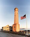 | San Francisco
(Alcatraz Adası ) | 37 ° 49′34.5″ K 122 ° 25′19.8″ B / 37.826250 ° K 122.422167 ° B / 37.826250; -122.422167 | 1854 (İlk)
1909 (Güncel) | 1963 | Aktif | DCB-24 | 214 214 ft (65 metre) |
| Anacapa Adası Işığı |  | Anacapa Adası | 34 ° 00′57 ″ K 119 ° 21′34 ″ B / 34.015827 ° K 119.359548 ° B / 34.015827; -119.359548 | 1912 (İlk)
1932 (Güncel) | 1967[1] | Aktif | DCB-24 | 277 277 ft (84 metre) |
| Ano Nuevo Işık | 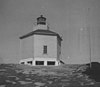 | Año Nuevo Adası | 37 ° 06′30″ K 122 ° 20′16 ″ B / 37.1083 ° K 122.3378 ° B / 37.1083; -122.3378
(Ada koordinatları) | 1890 (İlk)
1914 (Son) | Asla | 1948
(1976'da kesildi) | Yok | Bilinmeyen |
| Balast Noktası Işığı |  | San Diego
(Point Loma ) | 32 ° 41′11.0″ K 117 ° 13′57.0″ B / 32.686389 ° K 117.232500 ° B / 32.686389; -117.232500 | 1890 | Asla | 1960Bir
(Yıkıldı) | Yok | Bilinmeyen |
| Pil Noktası Işığı |  | Hilal Şehri | 41 ° 44′39 ″ N 124 ° 12′11 ″ B / 41,744094 ° K 124,203099 ° B / 41.744094; -124.203099 | 1856 | 1953 | Aktif
(Pasif: 1965-1982) | 375 mm | 077 77 ft (23 metre) |
| Cape Mendocino Işık |  | Sığınak Koyu | 40 ° 26′23.66″ K 124 ° 24′21.71″ B / 40.4399056 ° K 124.4060306 ° B / 40.4399056; -124.4060306 | 1868 | 1951 | 1971B
(Değiştirildi) | Yok | 422 422 ft (129 metre) |
| Carquinez Boğazı Işığı |  | Vallejo | 38 ° 04′04 ″ N 122 ° 12′50 ″ B / 38.067816 ° K 122.213832 ° B / 38.067816; -122.213832 | 1910 | Asla | 1951
(İşaret ile değiştirildi) | Yok | 056 56 ft (17 metre) |
| East Brother Island Light |  | Richmond | 37 ° 57′48″ K 122 ° 26′01 ″ B / 37.963233 ° K 122.433643 ° B / 37.963233; -122.433643 | 1874 | 1969 | Aktif | FA 251 | 061 61 ft (19 metre) |
| Farallon Adası Işık | 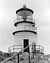 | San Francisco
(Farallon Adaları ) | 37 ° 41′56″ K 123 ° 00′06 ″ B / 37.698966 ° K 123.001651 ° B / 37.698966; -123.001651 | 1856 | 1972 | Aktif | VRB-25 | 358 358 ft (109 metre) |
| Fort Point Işığı | 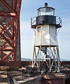 | San Francisco | 37 ° 48′38″ K 122 ° 28′38.4″ B / 37.81056 ° K 122.477333 ° B / 37.81056; -122.477333 | 1855 (İlk)
1864 (Güncel) | Asla | 1934
(İle ikame edilmiş köprü ) | Yok | 110 110 ft (34 metre) |
| Humboldt Liman Işığı | | Eureka
(Humboldt Körfezi ) | 40 ° 46′7.1″ K 124 ° 13′15.7″ B / 40.768639 ° K 124.221028 ° B / 40.768639; -124.221028 | 1856 | Asla | 1892
(1933'te çöktü) | Yok | 045 45 ft (14 metre) |
| Kireç Noktası Işık |  | San Francisco | 37 ° 49′32″ K 122 ° 28′42 ″ B / 37.825447 ° K 122.478321 ° B / 37.825447; -122.478321 | 1900 | 1961 | Aktif | Yok | 020 20 ft (6,1 m) |
| Lions Deniz Feneri | 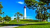 | Uzun sahil | 33 ° 45′37″ K 118 ° 11′39 ″ B / 33.7602334 ° K 118.1941101 ° B / 33.7602334; -118.1941101 | 2000[2] | Bilinmeyen | Bilinmeyen | Bilinmeyen | 065.62 65,62 ft (20,00 m)[2] |
| Uzun Plaj Işığı |  | Uzun sahil
(Long Beach Limanı ) | 33 ° 43′24″ K 118 ° 11′13 ″ B / 33.723237 ° K 118.186821 ° B / 33.723237; -118.186821 | 1949 | Her zaman | Aktif | Bilinmeyen | 050 50 ft (15 metre) |
| Los Angeles Liman Işığı |  | Los Angeles
(Los Angeles Limanı ) | 33 ° 42′31″ K 118 ° 15′06 ″ B / 33.70857 ° K 118.25160 ° B / 33.70857; -118.25160 | 1913 | 1973 | Aktif | DCB-24 | 073 73 ft (22 metre) |
| Mare Island Işık |  | Vallejo
(Mare Adası ) | 38 ° 04′29 ″ K 122 ° 15′02 ″ B / 38.074834 ° K 122.250464 ° B / 38.074834; -122.250464 | 1873 | Asla | 1917
(1930'larda yıkıldı) | Yok | 076 76 ft (23 metre) |
| Mile Rocks Işık |  | San Francisco | 37 ° 47′34″ K 122 ° 30′37 ″ B / 37.792765 ° K 122.510366 ° B / 37.792765; -122.510366 | 1906 | 1966 | Aktif | DCB-24 | 049 49 ft (15 metre) |
| Oakland Liman Işığı |  | Oakland | 37 ° 46′53 ″ K 122 ° 14′38 ″ B / 37.781335 ° K 122.243817 ° B / 37.781335; -122.243817 | 1890 (İlk)
1903 (Son) | Asla | 1966C | Yok | Bilinmeyen |
| Parkers 'Deniz Feneri | | Uzun sahil | 33 ° 45′36″ K 118 ° 11′31″ B / 33,7598744 ° K 118,1920629 ° B / 33.7598744; -118.1920629 | Bilinmeyen | Bilinmeyen | Bilinmeyen | Bilinmeyen | Bilinmeyen |
| Piedras Blancas Işık |  | San Simeon | 35 ° 39′56.3″ K 121 ° 17-03.6 ° B / 35.665639 ° K 121.284333 ° B / 35.665639; -121.284333 | 1875 | 1975 | Aktif | VRB-25 | 142 142 ft (43 metre) |
| Güvercin Noktası Işığı |  | Yarım Ay Körfezi | 37 ° 10′54.3″ K 122 ° 23′38.1″ B / 37.181750 ° K 122.393917 ° B / 37.181750; -122.393917 | 1872 | 1974 | Aktif | DCB-24 | 148 148 ft (45 metre) |
| Point Arena Işık |  | Point Arena | 38 ° 57′17.1″ K 123 ° 44′25.8″ B / 38.954750 ° K 123.740500 ° B / 38.954750; -123.740500 | 1870 (İlk)
1908 (Güncel) | 1977 | Aktif | DCB-224 | 155 155 ft (47 metre) |
| Point Arguello Işık |  | Lompoc
(Point Arguello ) | 34 ° 34′37.4″ K 120 ° 38′49.9″ B / 34,577056 ° K 120,647194 ° B / 34.577056; -120.647194 | 1901 (İlk)
1934 (Son) | 1934 | 1967D | Yok | 124 124 ft (38 metre) |
| Nokta Künt Işık |  | San Francisco
(Angel Adası ) | 37 ° 51′11.64″ K 122 ° 25′9.25″ B / 37.8532333 ° K 122.4192361 ° B / 37.8532333; -122.4192361 | 1915 (İlk)
1956 (Güncel) | 1976 | Aktif | Bilinmeyen | 060 60 ft (18 metre) |
| Point Bonita Light |  | San Francisco
(Point Bonita) | 37 ° 48′56″ K 122 ° 31′46 ″ B / 37.815614 ° K 122.529578 ° B / 37.815614; -122.529578 | 1855 (İlk)
1877 (Güncel) | 1980 | Aktif | İkinci emir Fresnel | 124 124 ft (38 metre) |
| Point Cabrillo Işığı |  | Caspar | 39 ° 20′54.97″ K 123 ° 49′34.02 ″ B / 39.3486028 ° K 123.8261167 ° B / 39.3486028; -123.8261167 | 1909 | 1973 | Aktif | Üçüncü dereceden Fresnel | 081 81 ft (25 metre) |
| Point Conception Light |  | Lompoc
(Nokta Kavramı ) | 34 ° 26′55.51″ K 120 ° 28′14.71″ B / 34.4487528 ° K 120.4707528 ° B / 34.4487528; -120.4707528 | 1856 (İlk)
1882 (Güncel) | 1973 | Aktif | VRB-25 | 133 133 ft (41 metre) |
| Point Diablo Light |  | San Francisco
(altın Kapı ) | 37 ° 49′13 ″ K 122 ° 29′58″ B / 37.820171 ° K 122.499423 ° B / 37.820171; -122.499423 | 1923 | Her zaman | Aktif | Bilinmeyen | Bilinmeyen |
| Nokta Fermin Işığı |  | Los Angeles
(San Pedro ) | 33 ° 42′20″ K 118 ° 17′37 ″ B / 33.705420 ° K 118.293649 ° B / 33.705420; -118.293649 | 1874 | Asla | 1942 | Yok | 120 120 ft (37 metre) |
| Point Hueneme Light | 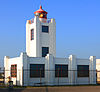 | Port Hueneme | 34 ° 08′43 ″ K 119 ° 12′36 ″ B / 34,145176 ° K 119,210019 ° B / 34.145176; -119.210019 | 1874 (İlk)
1941 (Güncel) | 1972 | Aktif | LED | 052 52 ft (16 metre) |
| Point Knox Light | | San Francisco | Yok | 1900 | Bilinmeyen | 1963
(Yıkıldı) | Yok | Bilinmeyen |
| Point Loma Light (eski) |  | San Diego
(Point Loma ) | 32 ° 40′19″ K 117 ° 14′27 ″ B / 32.671983 ° K 117.240938 ° B / 32.671983; -117.240938 | 1855E | Asla | 1891 | Üçüncü dereceden Fresnel
(Devre dışı bırakıldı) | 462 462 ft (141 metre) |
| Point Loma Light (yeni) |  | San Diego
(Point Loma ) | 32 ° 39′54″ K 117 ° 14′33″ B / 32.665071 ° K 117.242621 ° B / 32.665071; -117.242621 | 1891 | 1973 | Aktif | VLB-44 | 088 88 ft (27 metre) |
| Point Montara Işık |  | Montara | 37 ° 32′11 ″ K 122 ° 31′10 ″ B / 37,536503 ° K 122,519311 ° B / 37.536503; -122.519311 | 1900 (İlk)
1928 (Güncel) | 1970 | Aktif | FA 251 | 070 70 ft (21 metre) |
| Point Pinos Işığı | 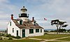 | Pacific Grove | 36 ° 38′00″ K 121 ° 56′02 ″ B / 36.633389 ° K 121.933783 ° B / 36.633389; -121.933783 | 1855 | 1975 | Aktif | Üçüncü dereceden Fresnel | 089 89 ft (27 metre) |
| Point Reyes Işık |  | Point Reyes İstasyonu
(Point Reyes ) | 37 ° 59′44 ″ K 123 ° 01′24 ″ B / 37.995621 ° K 123.023215 ° B / 37.995621; -123.023215 | 1870 | 1975 | Aktif | Birinci dereceden Fresnel | 265 265 ft (81 metre) |
| Point San Luis Işık |  | Avila Plajı | 35 ° 09′37 ″ N 120 ° 45′39 ″ B / 35.160362 ° K 120.760882 ° B / 35.160362; -120.760882 | 1890 | 1974 | 1975D | Yok | 116 116 ft (35 metre) |
| Point Sur Işık |  | Carmel-by-the-Sea | 36 ° 18′22.79″ K 121 ° 54′05.36″ B / 36.3063306 ° K 121.9014889 ° B / 36.3063306; -121.9014889 | 1889 | 1972 | Aktif | DCB-224 | 270 270 ft (82 metre) |
| Point Vicente Light |  | Rancho Palos Verdes | 33 ° 44′31″ K 118 ° 24′39 ″ B / 33.741867 ° K 118.410738 ° B / 33.741867; -118.410738 | 1926 | 1973 | Aktif | Üçüncü dereceden Fresnel | 155 155 ft (47 metre) |
| Punta Gorda Işık |  | Fortuna | 40 ° 14′58″ K 124 ° 21′01 ″ B / 40.249433 ° K 124.350220 ° B / 40.249433; -124.350220 | 1912 | Asla | 1951 | Yok | Bilinmeyen |
| Karaca Adası Işığı |  | Karaca Adası | 38 ° 04′04 ″ N 122 ° 01′41 ″ B / 38.067856 ° K 122.028166 ° B / 38.067856; -122.028166Koordinatlar: 38 ° 04′04 ″ N 122 ° 01′41 ″ B / 38.067856 ° K 122.028166 ° B / 38.067856; -122.028166 | 1891 | Asla | 1945
(Daha sonra yok edildi) | Yok | 041 41 ft (12 metre) |
| Rubicon Point Light |  | South Lake Tahoe | 38 ° 59′45″ K 120 ° 05′41″ B / 38.99583 ° K 120.09472 ° B / 38.99583; -120.09472 | 1919 | Asla | 1921 | Yok | 200 200 ft (61 metre) |
| Santa Barbara Işık |  | Santa Barbara | 34 ° 23′47″ K 119 ° 43′21″ B / 34.396320 ° K 119.722625 ° B / 34.396320; -119.722625 | 1856 (İlk)
1928 (Güncel) | 1928 | Aktif | Bilinmeyen | 142 142 ft (43 metre) |
| Santa Cruz Işık |  | Santa Cruz | 36 ° 57′05.34″ K 122 ° 01′36,36 ″ B / 36.9514833 ° K 122.0267667 ° B / 36.9514833; -122.0267667 | 1870 (İlk)
1967 (Güncel) | 1941 | Aktif? | Bilinmeyen | 060 60 ft (18 metre) |
| Santa Cruz Dalgakıran Işık |  | Santa Cruz
(Santa Cruz limanı ) | 36 ° 57′38.5″ K 122 ° 00′08.0 ″ B / 36.960694 ° K 122.002222 ° B / 36.960694; -122.002222 | 1964 (İlk)
2002 (Güncel) | Her zaman | Aktif | Bilinmeyen | 060 60 ft (18 metre) |
| Southampton Shoal Işık | 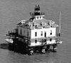 | San francisco bay | 37 ° 52′54.981″ K 122 ° 24′00.837″ B / 37.88193917 ° K 122.40023250 ° B / 37.88193917; -122.40023250 | 1905 | Asla | 1960
(Yat kulübüne taşındı) | Yok | Bilinmeyen |
| St. George Reef Işık | 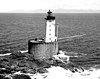 | Hilal Şehri | 41 ° 50′11 ″ K 124 ° 22′33 ″ B / 41.83633 ° K 124.37587 ° B / 41.83633; -124.37587 | 1892 | Asla | Aktif
(Pasif: 1975-2012) | Bilinmeyen | 146 146 ft (45 metre) |
| Şeker Çamı Noktası Işık | | Tahoma | 39 ° 03′41 ″ N 120 ° 06′50″ B / 39.061266 ° K 120.113971 ° B / 39.061266; -120.113971 | 1921 | Asla | 1985D | Yok | Bilinmeyen |
| Table Bluff Light |  | Table Bluff | 40 ° 41′45.02″ K 124 ° 16′26.16″ B / 40.6958389 ° K 124.2739333 ° B / 40.6958389; -124.2739333 | 1892 | 1953 | 1971 | Yok | Bilinmeyen |
| Trinidad Baş Işık |  | Trinidad | 41 ° 3′7.0″ K 124 ° 9′5.2 ″ B / 41.051944 ° K 124.151444 ° B / 41.051944; -124.151444 | 1871 | 1974 | Aktif | 375 mm | 196 196 ft (60 metre) |
| Yerba Buena Işık |  | San Francisco
Yerba Buena Adası | 37 ° 48′26.27″ K 122 ° 21′44.29″ B / 37.8072972 ° K 122.3623028 ° B / 37.8072972; -122.3623028 | 1875 | 1958 | Aktif | Bilinmeyen | 095 95 ft (29 metre) |


