| İsim | yer | Listelendiği Tarih | Izgara Ref. [not 1] | Coğrafi koordinatlar | Notlar | LB Numarası [not 2] | Resim |
|---|
| 26, 28 High Street | | | | 55 ° 58′37″ K 3 ° 35′50″ B / 55,976899 ° K 3,597313 ° B / 55.976899; -3.597313 (26, 28 High Street) | Kategori C (S) | 37435 |  |
| 74, 76 High Street | | | | 55 ° 58′37″ K 3 ° 35′56″ B / 55.97697 ° K 3.59879 ° B / 55.97697; -3.59879 (74, 76 High Street) | Kategori C (S) | 37446 | |
| Linlithgow Sarayı, Gate-House | | | | 55 ° 58′41″ K 3 ° 36′03 ″ B / 55.978083 ° K 3.600952 ° B / 55.978083; -3.600952 (Linlithgow Sarayı, Gate-House) | A Kategorisi | 37470 |  Başka bir resim yükle
Daha fazla görsele bakın |
| 19 Lion Well Wynd Ve Sınır Duvarı | | | | 55 ° 58′32″ K 3 ° 36′15 ″ B / 55.975435 ° K 3.604176 ° B / 55.975435; -3.604176 (19 Lion Well Wynd Ve Sınır Duvarı) | Kategori C (S) | 37475 | |
| 2 Kraliyet Terası | | | | 55 ° 58′31″ K 3 ° 36′11 ″ B / 55.975226 ° K 3.603029 ° B / 55.975226; -3.603029 (2 Kraliyet Terası) | Kategori C (S) | 37491 | |
| Edinburgh Road, St Magdalene's Distillery East Barns | | | | 55 ° 58′36 ″ K 3 ° 35′27″ B / 55.976631 ° K 3.590956 ° B / 55.976631; -3.590956 (Edinburgh Road, St Magdalene's Distillery East Barns) | Kategori C (S) | 37370 | |
| Friarsbrae, Rivalds Gatepiers ve Sınır Duvarlarıyla Yeşil Ev | | | | 55 ° 58′21″ K 3 ° 36′11 ″ B / 55.972636 ° K 3.603178 ° B / 55.972636; -3.603178 (Friarsbrae, Rivalds Gatepiers ve Sınır Duvarlarıyla Yeşil Ev) | Kategori B | 37377 | |
| Friarsbrae, Sınır Duvarları Olan Victoria Yeri | | | | 55 ° 58′27″ K 3 ° 36′07 ″ B / 55.974232 ° K 3.602027 ° B / 55.974232; -3.602027 (Friarsbrae, Sınır Duvarları Olan Victoria Yeri) | Kategori B | 37380 | |
| High Street, Adliye Binası | | | | 55 ° 58′35″ K 3 ° 36′05 ″ B / 55.976505 ° K 3.601383 ° B / 55.976505; -3.601383 (High Street, Adliye Binası) | Kategori B | 37400 | 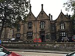 Başka bir resim yükle
|
| 103, 105 High Street | | | | 55 ° 58′35″ K 3 ° 36′07 ″ B / 55.976508 ° K 3.601816 ° B / 55.976508; -3.601816 (103, 105 High Street) | Kategori C (S) | 37402 | |
| 169-173 (Tek Numara) Yüksek Sokak | | | | 55 ° 58′34 ″ K 3 ° 36′17 ″ B / 55.976048 ° K 3.604714 ° B / 55.976048; -3.604714 (169-173 (Tek Numara) Yüksek Sokak) | Kategori C (S) | 37417 | |
| 201,203, 205 High Street | | | | 55 ° 58′33″ K 3 ° 36′21″ B / 55.975864 ° K 3.605748 ° B / 55.975864; -3.605748 (201,203, 205 High Street) | Kategori C (S) | 37420 | |
| 217-221 (Tek Sayılar) High Street | | | | 55 ° 58′33″ K 3 ° 36′22″ B / 55.975805 ° K 3.60613 ° B / 55.975805; -3.60613 (217-221 (Tek Sayılar) High Street) | Kategori C (S) | 37422 | |
| 293 High Street | | | | 55 ° 58′33″ K 3 ° 36′33″ B / 55.975791 ° K 3.609271 ° B / 55.975791; -3.609271 (293 High Street) | Kategori B | 37429 | 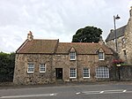 Başka bir resim yükle
|
| 2, 4 Ana Cadde | | | | 55 ° 58′37″ K 3 ° 35′47″ B / 55.977082 ° K 3.596407 ° B / 55.977082; -3.596407 (2, 4 Ana Cadde) | Kategori C (S) | 37432 | |
| Gatepiers ve Çevreleyen Duvarlarla Hiltly Çiftliği | | | | 55 ° 57′42″ K 3 ° 35′43″ B / 55.961615 ° K 3.595145 ° B / 55.961615; -3.595145 (Gatepiers ve Çevreleyen Duvarlarla Hiltly Çiftliği) | Kategori B | 12975 | |
| Linlithgow Köprüsü, 2-14 (Even Nos) Ana Cadde, Chalmers Evleri | | | | 55 ° 58′34 ″ K 3 ° 37′34″ B / 55.976199 ° K 3.626115 ° B / 55.976199; -3.626115 (Linlithgow Köprüsü, 2-14 (Even Nos) Ana Cadde, Chalmers Evleri) | Kategori B | 12976 | |
| Preston House Lodge - Kapılar ve Ağ Geçişleri | | | | 55 ° 57′59 ″ K 3 ° 36′18″ B / 55.966267 ° K 3.60503 ° B / 55.966267; -3.60503 (Preston House Lodge - Kapılar ve Ağ Geçişleri) | Kategori B | 12984 | |
| Bonnytoun Evleri | | | | 55 ° 59′23″ K 3 ° 35′27″ B / 55.989634 ° K 3.590913 ° B / 55.989634; -3.590913 (Bonnytoun Evleri) | Kategori C (S) | 7470 | |
| Bridgend Çiftliği | | | | 55 ° 58′08″ K 3 ° 32'04 ″ B / 55.968783 ° K 3.534538 ° B / 55.968783; -3.534538 (Bridgend Çiftliği) | Kategori B | 7472 | |
| Champfleurie Ev Çiftliği | | | | 55 ° 58′17 ″ K 3 ° 32′50 ″ B / 55.97132 ° K 3.547233 ° B / 55.97132; -3.547233 (Champfleurie Ev Çiftliği) | Kategori B | 7477 | |
| Lodge, Gatepier ve Sınır Duvarı ile Champfleurie Evi | | | | 55 ° 58′14 ″ K 3 ° 32′51″ B / 55.970462 ° K 3.547567 ° B / 55.970462; -3.547567 (Lodge, Gatepier ve Sınır Duvarı ile Champfleurie Evi) | Kategori B | 7478 | |
| Eski Okul Binası Dahil Edinburgh Road Kingscavil Evleri | | | | 55 ° 58′18″ K 3 ° 33′20″ B / 55.971531 ° K 3.555461 ° B / 55.971531; -3.555461 (Eski Okul Binası Dahil Edinburgh Road Kingscavil Evleri) | A Kategorisi | 7482 |  Başka bir resim yükle
|
| 36, 36A Yüksek Sokak | | | | 55 ° 58′37″ K 3 ° 35′51″ B / 55.976869 ° K 3.597584 ° B / 55.976869; -3.597584 (36, 36A Yüksek Sokak) | Kategori B | 37437 |  Başka bir resim yükle
|
| 50 High Street Red Lion Inn | | | | 55 ° 58′37″ K 3 ° 35′53″ B / 55.976864 ° K 3.597936 ° B / 55.976864; -3.597936 (50 High Street Red Lion Inn) | Kategori B | 37440 | |
| 100 High Street | | | | 55 ° 58′38″ K 3 ° 35′59″ B / 55.977192 ° K 3.599697 ° B / 55.977192; -3.599697 (100 High Street) | Kategori C (S) | 37450 | |
| 114 High Street | | | | 55 ° 58′38″ K 3 ° 36′00 ″ B / 55.977151 ° K 3.600064 ° B / 55.977151; -3.600064 (114 High Street) | Kategori C (S) | 37452 | |
| 232, 234 ve 236 High Street | | | | 55 ° 58′34 ″ K 3 ° 36′19″ B / 55.976167 ° K 3.605264 ° B / 55.976167; -3.605264 (232, 234 ve 236 High Street) | Kategori B | 37459 |  Başka bir resim yükle
|
| 2 Kirkgate | | | | 55 ° 58′39 ″ K 3 ° 36′04 ″ B / 55.977525 ° K 3.601009 ° B / 55.977525; -3.601009 (2 Kirkgate) | Kategori B | 37463 | |
| Kirkgate, Duvarlar | | | | 55 ° 58′40″ K 3 ° 36′03 ″ B / 55.977797 ° K 3.60086 ° B / 55.977797; -3.60086 (Kirkgate, Duvarlar) | Kategori B | 37467 | |
| Manse Yolu, Kanal Havzası, Evler ve Ahırlar | | | | 55 ° 58′30″ K 3 ° 35′54″ B / 55.974882 ° K 3.598335 ° B / 55.974882; -3.598335 (Manse Yolu, Kanal Havzası, Evler ve Ahırlar) | Kategori B | 37479 | |
| Manse Yolu Kanal Evi, Gig House Gatepiers ve Sınır Duvarı ile | | | | 55 ° 58′30″ K 3 ° 35′56″ B / 55,974892 ° K 3,598993 ° B / 55.974892; -3.598993 (Manse Yolu Kanal Evi, Gig House Gatepiers ve Sınır Duvarı ile) | Kategori B | 37480 | |
| Manse Yolu, Edinburgh ve Glasgow Union Kanal Köprüsü 43 | | | | 55 ° 58′31″ K 3 ° 35′50″ B / 55.975183 ° K 3.59729 ° B / 55.975183; -3.59729 (Manse Yolu, Edinburgh ve Glasgow Union Kanal Köprüsü 43) | Kategori B | 37482 | 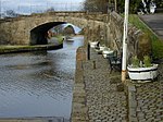 Başka bir resim yükle
Daha fazla görsele bakın |
| 5 Sınır Duvarlı Birlik Yolu | | | | 55 ° 58′32″ K 3 ° 36′17 ″ B / 55.975483 ° K 3.604674 ° B / 55.975483; -3.604674 (5 Sınır Duvarlı Birlik Yolu) | Kategori C (S) | 37502 | |
| 26 Batı Limanı | | | | 55 ° 58′34 ″ K 3 ° 36′43″ B / 55.97599 ° K 3.611971 ° B / 55.97599; -3.611971 (26 Batı Limanı) | Kategori C (S) | 37507 | |
| Bathgate Yolu, Ashley Hall | | | | 55 ° 58′30″ K 3 ° 36′42″ B / 55.974978 ° K 3.611705 ° B / 55.974978; -3.611705 (Bathgate Yolu, Ashley Hall) | Kategori B | 37355 | |
| 23 High Street | | | | 55 ° 58′36 ″ K 3 ° 35′51″ B / 55.976554 ° K 3.597571 ° B / 55.976554; -3.597571 (23 High Street) | Kategori C (S) | 37384 | |
| 49, 51 High Street | | | | 55 ° 58′36 ″ K 3 ° 35′56″ B / 55.976618 ° K 3.598904 ° B / 55.976618; -3.598904 (49, 51 High Street) | Kategori B | 37389 |  Başka bir resim yükle
|
| 63 Korkuluklu Yüksek Cadde | | | | 55 ° 58′36 ″ K 3 ° 35′59″ B / 55.976681 ° K 3.599596 ° B / 55.976681; -3.599596 (63 Korkuluklu Yüksek Cadde) | Kategori B | 37393 |  Başka bir resim yükle
|
| 107, 109 High Street | | | | 55 ° 58′35″ K 3 ° 36′07 ″ B / 55.976443 ° K 3.60199 ° B / 55.976443; -3.60199 (107, 109 High Street) | Kategori C (S) | 37403 | |
| 111, 113 High Street, Futbol ve Kriketçiler Kolları | | | | 55 ° 58′35″ K 3 ° 36′08 ″ B / 55.976405 ° K 3.602196 ° B / 55.976405; -3.602196 (111, 113 High Street, Futbol ve Kriketçiler Kolları) | Kategori C (S) | 37404 | |
| 115 High Street, Futbol ve Kriketçiler Kolları | | | | 55 ° 58′35″ K 3 ° 36′08 ″ B / 55.97634 ° K 3.60229 ° B / 55.97634; -3.60229 (115 High Street, Futbol ve Kriketçiler Kolları) | Kategori C (S) | 37405 | |
| 129 Yüksek Sokak | | | | 55 ° 58′34 ″ K 3 ° 36′11 ″ B / 55.976233 ° K 3.602943 ° B / 55.976233; -3.602943 (129 Yüksek Sokak) | Kategori B | 37407 |  Başka bir resim yükle
|
| 137-141 (Tek Numaralar) High Street | | | | 55 ° 58′33″ K 3 ° 36′12 ″ B / 55.975968 ° K 3.603284 ° B / 55.975968; -3.603284 (137-141 (Tek Numaralar) High Street) | Kategori C (S) | 37409 | |
| Kış Bahçesi, Teras Bahçesi, Pavyonlar, Sundurma ve Güneş Saati ile Grange Evi | | | | 55 ° 59′29 ″ K 3 ° 36′15 ″ B / 55.991421 ° K 3.604196 ° B / 55.991421; -3.604196 (Kış Bahçesi, Teras Bahçesi, Pavyonlar, Sundurma ve Güneş Saati ile Grange Evi) | A Kategorisi | 12972 | |
| Linlithgow Köprüsü, Ana Cadde, Halk Salonu (Topluluk Merkezi) | | | | 55 ° 58′33″ K 3 ° 37′35″ B / 55.975764 ° K 3.626385 ° B / 55.975764; -3.626385 (Linlithgow Köprüsü, Ana Cadde, Halk Salonu (Topluluk Merkezi)) | Kategori B | 12977 | |
| Woodcockdale, Edinburgh ve Glasgow Union Canal Ahırları ve Evleri | | | | 55 ° 57′54 ″ K 3 ° 38′32″ B / 55.965103 ° K 3.642215 ° B / 55.965103; -3.642215 (Woodcockdale, Edinburgh ve Glasgow Union Canal Ahırları ve Evleri) | A Kategorisi | 12989 |  Başka bir resim yükle
Daha fazla görsele bakın |
| Burghmuir Çiftlik Evi ve Horsemill ile Dümen | | | | 55 ° 59′06 ″ K 3 ° 34′10″ B / 55.984924 ° K 3.56932 ° B / 55.984924; -3.56932 (Burghmuir Çiftlik Evi ve Horsemill ile Sürüş) | Kategori C (S) | 7475 | |
| Paskalya Karayip Çiftliği Ve Yönlendirme | | | | 55 ° 57′26″ K 3 ° 39′05 ″ B / 55.957171 ° K 3.651442 ° B / 55.957171; -3.651442 (Paskalya Karayip Çiftliği Ve Yönlendirme) | Kategori B | 7481 | |
| Union Road, Demiryolu Duvarı (N Hattan) E'ye Demiryolu Köprüsü Dahil | | | | 55 ° 58′33″ K 3 ° 36′02 ″ B / 55.975833 ° K 3.600554 ° B / 55.975833; -3.600554 (Union Road, Demiryolu Duvarı (N Hattan) E'ye Demiryolu Köprüsü Dahil) | Kategori C (S) | 46268 | |
| 70, 72 High Street | | | | 55 ° 58′37″ K 3 ° 35′55″ B / 55.976945 ° K 3.598661 ° B / 55.976945; -3.598661 (70, 72 High Street) | Kategori C (S) | 37445 | |
| 212, 214 High Street | | | | 55 ° 58′35″ K 3 ° 36′16 ″ B / 55.976359 ° K 3.60431 ° B / 55.976359; -3.60431 (212, 214 High Street) | Kategori B | 37453 |  Başka bir resim yükle
|
| 246, 248 High Street | | | | 55 ° 58′34 ″ K 3 ° 36′21″ B / 55.976214 ° K 3.605762 ° B / 55.976214; -3.605762 (246, 248 High Street) | Kategori C (S) | 37461 | |
| Kirkgate, Rosegarden, Linlithgow 1. Marki Heykeli | | | | 55 ° 58′40″ K 3 ° 36′00 ″ B / 55.977755 ° K 3.599912 ° B / 55.977755; -3.599912 (Kirkgate, Rosegarden, Linlithgow 1. Marki Heykeli) | Kategori B | 37466 | 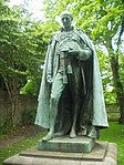 Başka bir resim yükle
|
| 13 Lion Well Wynd | | | | 55 ° 58′33″ K 3 ° 36′15 ″ B / 55.975785 ° K 3.604238 ° B / 55.975785; -3.604238 (13 Lion Well Wynd) | Kategori B | 37473 | |
| Maltings, Köşe Ana Yolu ve Moray Yolu, Şebeke ve Kulübeler | | | | 55 ° 58′21″ K 3 ° 37′15 ″ B / 55.972367 ° K 3.620954 ° B / 55.972367; -3.620954 (Maltings, Köşe Ana Yolu ve Moray Yolu, Şebeke ve Kulübeler) | Kategori C (S) | 37478 | |
| Manse Yolu, Ağ Geçitli Clarendon Evi, Sınır Duvarları ve Ahırları | | | | 55 ° 58′24″ K 3 ° 35′38″ B / 55.973205 ° K 3.593956 ° B / 55.973205; -3.593956 (Manse Yolu, Ağ Geçitli Clarendon Evi, Sınır Duvarları ve Ahırları) | Kategori B | 37481 | |
| 7, 7A Kraliyet Terası, Tarihi Binalar, Kapılar, Kapılar, Korkuluklar ve Sınır Duvarı | | | | 55 ° 58′29 ″ K 3 ° 36′15 ″ B / 55.974826 ° K 3.60407 ° B / 55.974826; -3.60407 (7, 7A Kraliyet Terası, Tarihi Binalar, Kapılar, Kapılar, Korkuluklar ve Sınır Duvarı) | Kategori B | 37493 | |
| Geçidi ve Livingston Mezar Kasası ile St Michael's Parish Kilisesi (İskoçya Kilisesi) | | | | 55 ° 58′41″ K 3 ° 36′01 ″ B / 55.978136 ° K 3.600329 ° B / 55.978136; -3.600329 (Geçidi ve Livingston Mezar Kasası ile St Michael's Parish Kilisesi (İskoçya Kilisesi)) | A Kategorisi | 37499 |  Başka bir resim yükle
Daha fazla görsele bakın |
| Union Road, St John's Evanjelist Kilisesi | | | | 55 ° 58′30″ K 3 ° 36′26″ B / 55.975128 ° K 3.607096 ° B / 55.975128; -3.607096 (Union Road, St John's Evanjelist Kilisesi) | Kategori C (S) | 37505 | |
| 12, 14 West Port The Black Bitch Otel | | | | 55 ° 58′33″ K 3 ° 36′40″ B / 55.975929 ° K 3.611103 ° B / 55.975929; -3.611103 (12, 14 West Port The Black Bitch Otel) | Kategori C (S) | 37506 | 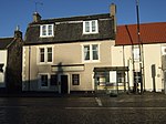 Başka bir resim yükle
|
| Duvarlı Bahçe Ve Süs Yığını Olan Bonnytoun Ev | | | | 55 ° 59′08″ K 3 ° 35′11 ″ B / 55.985596 ° K 3.586274 ° B / 55.985596; -3.586274 (Duvarlı Bahçe Ve Süs Yığını Olan Bonnytoun Ev) | Kategori B | 37360 | |
| Braehead, Edinburgh ve Glasgow Union Kanal Köprüsü 46 | | | | 55 ° 58′07 ″ K 3 ° 36′49″ B / 55.968519 ° K 3.613567 ° B / 55.968519; -3.613567 (Braehead, Edinburgh ve Glasgow Union Kanal Köprüsü 46) | Kategori B | 37361 | 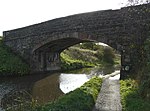 Başka bir resim yükle
|
| 9-17 ve 19-21 (Tek Numaralar) High Street | | | | 55 ° 58′36 ″ K 3 ° 35′49″ B / 55,976572 ° K 3,596915 ° B / 55.976572; -3.596915 (9-17 ve 19-21 (Tek Numaralar) High Street) | Kategori B | 37382 |  Başka bir resim yükle
|
| 69, 71 High Street | | | | 55 ° 58′36 ″ K 3 ° 36′00 ″ B / 55,976757 ° K 3,599967 ° B / 55.976757; -3.599967 (69, 71 High Street) | Kategori C (S) | 37395 | |
| High Street, Polis Karakolu | | | | 55 ° 58′34 ″ K 3 ° 36′05 ″ B / 55.976092 ° K 3.601334 ° B / 55.976092; -3.601334 (High Street, Polis Karakolu) | Kategori C (S) | 37401 |  Başka bir resim yükle
|
| 123-127 (Tek Numaralar) High Street | | | | 55 ° 58′35″ K 3 ° 36′10 ″ B / 55.976262 ° K 3.602768 ° B / 55.976262; -3.602768 (123-127 (Tek Numaralar) High Street) | Kategori B | 37406 |  Başka bir resim yükle
|
| 131-135 High Street | | | | 55 ° 58′34 ″ K 3 ° 36′11 ″ B / 55.976151 ° K 3.603035 ° B / 55.976151; -3.603035 (131-135 High Street) | Kategori B | 37408 | 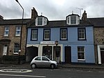 Başka bir resim yükle
|
| 143 High Street, Annet Evi | | | | 55 ° 58′34 ″ K 3 ° 36′12 ″ B / 55.9762 ° K 3.603422 ° B / 55.9762; -3.603422 (143 High Street, Annet Evi) | Kategori B | 37410 |  Başka bir resim yükle
|
| 149 High Street | | | | 55 ° 58′34 ″ K 3 ° 36′14″ B / 55.976177 ° K 3.603774 ° B / 55.976177; -3.603774 (149 High Street) | Kategori C (S) | 37413 | |
| High Street, St Peter`S (Episcopal) Kilisesi | | | | 55 ° 58′34 ″ K 3 ° 36′14″ B / 55.976085 ° K 3.603962 ° B / 55.976085; -3.603962 (High Street, St Peter`S (Episcopal) Kilisesi) | Kategori B | 37414 | 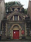 Başka bir resim yükle
|
| 175 High Street | | | | 55 ° 58′34 ″ K 3 ° 36′17 ″ B / 55.975975 ° K 3.604855 ° B / 55.975975; -3.604855 (175 High Street) | Kategori C (S) | 37418 | |
| 263, 265 (Tek Sayılar) Yüksek Sokak | | | | 55 ° 58′33″ K 3 ° 36′28″ B / 55.975845 ° K 3.607911 ° B / 55.975845; -3.607911 (263, 265 (Tek Sayılar) Yüksek Sokak) | Kategori B | 37425 | 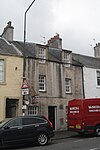 Başka bir resim yükle
|
| 10-18 (Hatta Nos) High Street | | | | 55 ° 58′37″ K 3 ° 35′48″ B / 55.976996 ° K 3.596788 ° B / 55.976996; -3.596788 (10-18 (Hatta Nos) High Street) | Kategori C (S) | 37433 | |
| Gateside Yönlendirme | | | | 55 ° 57′56″ K 3 ° 31′28″ B / 55.965691 ° K 3.524498 ° B / 55.965691; -3.524498 (Gateside Yönlendirme) | Kategori B | 12971 |  Başka bir resim yükle
|
| Williamcraigs Evi, Bahçe Pavyonu ve Ağ Geçitleri | | | | 55 ° 57′38″ K 3 ° 37′35″ B / 55.960667 ° K 3.626408 ° B / 55.960667; -3.626408 (Williamcraigs Evi, Bahçe Pavyonu ve Ağ Geçitleri) | Kategori B | 12987 | |
| 20-24 (Hatta Nos) High Street | | | | 55 ° 58′37″ K 3 ° 35′50″ B / 55.976901 ° K 3.597153 ° B / 55.976901; -3.597153 (20-24 (Hatta Nos) High Street) | Kategori B | 37434 | |
| 30-34 (Hatta Nos) High Street | | | | 55 ° 58′37″ K 3 ° 35′51″ B / 55.976825 ° K 3.59747 ° B / 55.976825; -3.59747 (30-34 (Hatta Nos) High Street) | Kategori B | 37436 | |
| 52 ve 54 High Street | | | | 55 ° 58′37″ K 3 ° 35′53″ B / 55.976872 ° K 3.598065 ° B / 55.976872; -3.598065 (52 ve 54 High Street) | Kategori B | 37441 | |
| 82-86 (Hatta Nos) High Street | | | | 55 ° 58′37″ K 3 ° 35′57″ B / 55.977003 ° K 3.599032 ° B / 55.977003; -3.599032 (82-86 (Hatta Nos) High Street) | Kategori C (S) | 37448 | |
| 222, 224 High Street | | | | 55 ° 58′35″ K 3 ° 36′17 ″ B / 55.97629 ° K 3.604788 ° B / 55.97629; -3.604788 (222, 224 High Street) | Kategori C (S) | 37457 | |
| 238 High Street | | | | 55 ° 58′34 ″ K 3 ° 36′20″ B / 55.976209 ° K 3.60549 ° B / 55.976209; -3.60549 (238 High Street) | Kategori C (S) | 37460 | |
| 258, 260 High Street | | | | 55 ° 58′34 ″ K 3 ° 36′22″ B / 55.976147 ° K 3.606064 ° B / 55.976147; -3.606064 (258, 260 High Street) | Kategori C (S) | 37462 | |
| Learmonth Bahçeleri, Dovecot | | | | 55 ° 58′32″ K 3 ° 35′54″ B / 55.97568 ° K 3.598465 ° B / 55.97568; -3.598465 (Learmonth Bahçeleri, Dovecot) | A Kategorisi | 37468 | 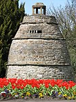 Başka bir resim yükle
Daha fazla görsele bakın |
| Linlithgow Sarayı ve Çeşmesi | | | | 55 ° 58′43 ″ K 3 ° 36′03 ″ B / 55.978695 ° K 3.600897 ° B / 55.978695; -3.600897 (Linlithgow Sarayı ve Çeşmesi) | A Kategorisi | 37469 | 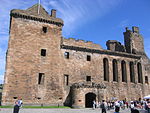 Başka bir resim yükle
Daha fazla görsele bakın |
| Lion Well Wynd Duvarları | | | | 55 ° 58′33″ K 3 ° 36′16 ″ B / 55.975792 ° K 3.604367 ° B / 55.975792; -3.604367 (Lion Well Wynd Duvarları) | Kategori C (S) | 37477 | |
| Manse Yolu, Kapılı Friarbank, Geçit Kapıları ve Sınır Duvarı | | | | 55 ° 58′23″ K 3 ° 35′51″ B / 55.973157 ° K 3.597607 ° B / 55.973157; -3.597607 (Manse Yolu, Kapılı Friarbank, Geçit Kapıları ve Sınır Duvarı) | Kategori B | 37483 | |
| Manse Yolu, Nether Parkley | | | | 55 ° 58′21″ K 3 ° 35′54″ B / 55.97258 ° K 3.598465 ° B / 55.97258; -3.598465 (Manse Yolu, Nether Parkley) | Kategori B | 37485 | |
| Manse Yolu, Nether Parkley Lodge, Gatepiers ve Sınır Duvarları | | | | 55 ° 58′19 ″ K 3 ° 35′51″ B / 55,97182 ° K 3,597472 ° B / 55.97182; -3.597472 (Manse Yolu, Nether Parkley Lodge, Gatepiers ve Sınır Duvarları) | Kategori B | 37486 | |
| Preston Yolu, Poldrait | | | | 55 ° 58′11 ″ K 3 ° 36′19″ B / 55.969761 ° K 3.605175 ° B / 55.969761; -3.605175 (Preston Yolu, Poldrait) | Kategori B | 37489 | |
| Sınır Duvarları ve İskeleleri Olan 13 Kraliyet Terası | | | | 55 ° 58′28″ K 3 ° 36′17 ″ B / 55.974519 ° K 3.604843 ° B / 55.974519; -3.604843 (Sınır Duvarları ve İskeleleri Olan 13 Kraliyet Terası) | Kategori C (S) | 37496 | |
| 14 Sınır Duvarları ve İskeleleri Olan Kraliyet Terası | | | | 55 ° 58′29 ″ K 3 ° 36′18″ B / 55.974695 ° K 3.605106 ° B / 55.974695; -3.605106 (14 Sınır Duvarları ve İskeleleri Olan Kraliyet Terası) | Kategori B | 37497 | |
| St Michael's Wynd Arka 23 High Street | | | | 55 ° 58′35″ K 3 ° 35′51″ B / 55.976439 ° K 3.597502 ° B / 55.976439; -3.597502 (St Michael's Wynd Arka 23 High Street) | Kategori C (S) | 37500 | |
| 4, 4A, 5, 5A Çilek Bankası | | | | 55 ° 58′31″ K 3 ° 36′08 ″ B / 55.975335 ° K 3.602232 ° B / 55.975335; -3.602232 (4, 4A, 5, 5A Çilek Bankası) | Kategori C (S) | 37501 | |
| Haç ve Kirkgate, Burgh Salonları (Eski Şehir Evi ve Eski Köy Binası) | | | | 55 ° 58′39 ″ K 3 ° 36′02 ″ B / 55.977414 ° K 3.600555 ° B / 55.977414; -3.600555 (Haç ve Kirkgate, Burgh Salonları (Eski Şehir Evi ve Eski Köy Binası)) | A Kategorisi | 37362 | 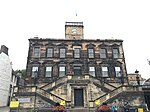 Başka bir resim yükle
|
| 13, 14 Haç | | | | 55 ° 58′38″ K 3 ° 36′00 ″ B / 55.977205 ° K 3.600098 ° B / 55.977205; -3.600098 (13, 14 Haç) | Kategori C (S) | 37366 | |
| Edinburgh Road, Edinburgh ve Glasgow Union Canal Su Kemeri | | | | 55 ° 58′33″ K 3 ° 35′05 ″ B / 55.975965 ° K 3.584742 ° B / 55.975965; -3.584742 (Edinburgh Road, Edinburgh ve Glasgow Union Canal Su Kemeri) | Kategori B | 37368 | |
| Falkirk Yolu, St Ninian'ın Craigmailen Kilisesi, Sınır Duvarı ve Geçitler | | | | 55 ° 58′34 ″ K 3 ° 36′49″ B / 55.976003 ° K 3.613718 ° B / 55.976003; -3.613718 (Falkirk Yolu, St Ninian'ın Craigmailen Kilisesi, Sınır Duvarı ve Geçitler) | Kategori B | 37373 | |
| Falkirk Road, Westerpark, Eski Coach-House | | | | 55 ° 58′31″ K 3 ° 36′53 ″ B / 55.975344 ° K 3.614637 ° B / 55.975344; -3.614637 (Falkirk Road, Westerpark, Eski Coach-House) | Kategori C (S) | 37374 | |
| Friarsbrae, Douglas Cottage (Eski Douglas Cottage Okulu) | | | | 55 ° 58′28″ K 3 ° 36′06 ″ B / 55.974399 ° K 3.601617 ° B / 55.974399; -3.601617 (Friarsbrae, Douglas Cottage (Eski Douglas Cottage Okulu)) | Kategori B | 37375 | |
| Friarsbrae, Rosemount | | | | 55 ° 58′27″ K 3 ° 36′04 ″ B / 55.974226 ° K 3.601145 ° B / 55.974226; -3.601145 (Friarsbrae, Rosemount) | Kategori B | 37379 | |
| 33-37 (Tek Numaralar) High Street | | | | 55 ° 58′36 ″ K 3 ° 35′54″ B / 55.976546 ° K 3.598212 ° B / 55.976546; -3.598212 (33-37 (Tek Numaralar) High Street) | Kategori C (S) | 37386 | |
| 65, 67 High Street, Dört Meryem | | | | 55 ° 58′36 ″ K 3 ° 35′59″ B / 55,976795 ° K 3,599793 ° B / 55.976795; -3.599793 (65, 67 High Street, Dört Meryem) | Kategori C (S) | 37394 |  Başka bir resim yükle
Daha fazla görsele bakın |
| 161, 161C, 163 High Street | | | | 55 ° 58′34 ″ K 3 ° 36′16 ″ B / 55.976098 ° K 3.604315 ° B / 55.976098; -3.604315 (161, 161C, 163 High Street) | Kategori C (S) | 37415 | |
| High Street, New Well | | | | 55 ° 58′33″ K 3 ° 36′25″ B / 55.975903 ° K 3.606935 ° B / 55.975903; -3.606935 (High Street, New Well) | Kategori C (S) | 37423 | |
| 303 ila 313 ve 315 ve 325 (Tek Sayılar) Ana Cadde ve Geçit | | | | 55 ° 58′32″ K 3 ° 36′38″ B / 55.975612 ° K 3.610641 ° B / 55.975612; -3.610641 (303 ila 313 ve 315 ve 325 (Tek Sayılar) Ana Cadde ve Geçit) | Kategori B | 37431 | 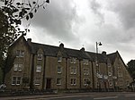 Başka bir resim yükle
|
| Ochiltree Castle & Castlegate (Eski Ochiltree Place) Sınır Duvarı ile | | | | 55 ° 57′22″ K 3 ° 33-03 ″ B / 55.956087 ° K 3.550902 ° B / 55.956087; -3.550902 (Ochiltree Castle & Castlegate (Eski Ochiltree Place) Sınır Duvarı ile) | A Kategorisi | 12978 | |
| Pardovan, Edinburgh ve Glasgow Union Kanal Köprüsü 40 | | | | 55 ° 58′36 ″ K 3 ° 32′21″ B / 55,976643 ° K 3,53908 ° B / 55.976643; -3.53908 (Pardovan, Edinburgh ve Glasgow Union Kanal Köprüsü 40) | Kategori B | 12979 | |
| Park, Edinburgh ve Glasgow Union Kanal Köprüsü 41 | | | | 55 ° 58′34 ″ K 3 ° 33′28″ B / 55.976075 ° K 3.557791 ° B / 55.976075; -3.557791 (Park, Edinburgh ve Glasgow Union Kanal Köprüsü 41) | Kategori B | 12980 | 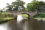 Başka bir resim yükle
Daha fazla görsele bakın |
| Philipstoun Ana Cadde Pardovan Kilisesi | | | | 55 ° 58′36 ″ K 3 ° 31′42″ B / 55.976679 ° K 3.528248 ° B / 55.976679; -3.528248 (Philipstoun Ana Cadde Pardovan Kilisesi) | Kategori B | 12982 | |
| 48 Woodcockvale, Edinburgh ve Glasgow Union Kanal Köprüsü 48 | | | | 55 ° 57′52″ K 3 ° 38′42″ B / 55.964456 ° K 3.64496 ° B / 55.964456; -3.64496 (48 Woodcockvale, Edinburgh ve Glasgow Union Kanal Köprüsü 48) | Kategori B | 12988 | |
| Belsyde Evi, Köşklü, Geçitli ve Sınır Duvarlı | | | | 55 ° 57′41″ K 3 ° 38′39″ B / 55.961457 ° K 3.644095 ° B / 55.961457; -3.644095 (Belsyde Köşklü, Ağ Geçitli ve Sınır Duvarlı Ev) | Kategori B | 7469 | |
| Falkirk Yolu, Longcroft Evi | | | | 55 ° 58′40″ K 3 ° 37′02 ″ B / 55.977734 ° K 3.617348 ° B / 55.977734; -3.617348 (Falkirk Yolu, Longcroft Evi) | Kategori B | 7483 | |
| Linlithgow Sarayı, Orman Evi | | | | 55 ° 58′41″ K 3 ° 36′05 ″ B / 55.978014 ° K 3.60143 ° B / 55.978014; -3.60143 (Linlithgow Sarayı, Orman Evi) | Kategori C (S) | 37471 |  Başka bir resim yükle
|
| Linlithgow Tren İstasyonu | | | | 55 ° 58′35″ K 3 ° 35′45″ B / 55.976468 ° K 3.595933 ° B / 55.976468; -3.595933 (Linlithgow Tren İstasyonu) | Kategori C (S) | 37472 |  Başka bir resim yükle
Daha fazla görsele bakın |
| 17 Lion Well Wynd Ve Sınır Duvarı | | | | 55 ° 58′33″ K 3 ° 36′15 ″ B / 55.975731 ° K 3.60422 ° B / 55.975731; -3.60422 (17 Lion Well Wynd Ve Sınır Duvarı) | Kategori B | 37474 | |
| Sınır Duvarları ve Kapıları Olan 10 ve 11 Kraliyet Terası | | | | 55 ° 58′30″ K 3 ° 36′16 ″ B / 55.974866 ° K 3.604408 ° B / 55.974866; -3.604408 (Sınır Duvarları ve Kapıları Olan 10 ve 11 Kraliyet Terası) | Kategori B | 37495 | |
| Wilcoxholm, Edinburgh ve Glasgow Union Kanal Köprüsü 42 | | | | 55 ° 58′38″ K 3 ° 34′21″ B / 55.977227 ° K 3.572518 ° B / 55.977227; -3.572518 (Wilcoxholm, Edinburgh ve Glasgow Union Kanal Köprüsü 42) | Kategori B | 37508 | 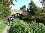 Başka bir resim yükle
Daha fazla görsele bakın |
| 11 Haç | | | | 55 ° 58′38″ K 3 ° 36′01 ″ B / 55.977284 ° K 3.60023 ° B / 55.977284; -3.60023 (11 Haç) | Kategori C (S) | 37364 | |
| Haç, Kaide ve Hatıra Taşı ile Kuyu Geçişi | | | | 55 ° 58′38″ K 3 ° 36′02 ″ B / 55.977108 ° K 3.600591 ° B / 55.977108; -3.600591 (Haç, Kaide ve Hatıra Taşı ile Kuyu Geçişi) | Kategori B | 37367 |  Başka bir resim yükle
|
| Falkirk Road, Longcroft House Gatepiers ve Sınır Duvarı | | | | 55 ° 58′33″ K 3 ° 36′47 ″ B / 55.975921 ° K 3.613058 ° B / 55.975921; -3.613058 (Falkirk Road, Longcroft House Gatepiers ve Sınır Duvarı) | Kategori C (S) | 37372 | |
| Friarsbrae, Edinburgh ve Glasgow Union Kanal Köprüsü 44 | | | | 55 ° 58′28″ K 3 ° 36′10 ″ B / 55.974368 ° K 3.602657 ° B / 55.974368; -3.602657 (Friarsbrae, Edinburgh ve Glasgow Union Kanal Köprüsü 44) | Kategori B | 37376 |  Başka bir resim yükle
|
| Friarsbrae, Rivaldsgreen Antrenör Evi | | | | 55 ° 58′21″ K 3 ° 36′10 ″ B / 55.97263 ° K 3.60289 ° B / 55.97263; -3.60289 (Friarsbrae, Rivaldsgreen Antrenör Evi) | Kategori C (S) | 37378 | |
| 39,41 High Street | | | | 55 ° 58′36 ″ K 3 ° 35′54″ B / 55.976588 ° K 3.598422 ° B / 55.976588; -3.598422 (39,41 High Street) | Kategori B | 37387 | 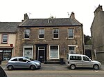 Başka bir resim yükle
|
| 43-47 (Tek Sayılar) High Street | | | | 55 ° 58′36 ″ K 3 ° 35′56″ B / 55.976584 ° K 3.598758 ° B / 55.976584; -3.598758 (43-47 (Tek Sayılar) High Street) | Kategori B | 37388 |  Başka bir resim yükle
|
| High Street, Ekran Duvar Lambası Standartları ve Provost'un Lambası ile İlçe Binaları | | | | 55 ° 58′35″ K 3 ° 36′03 ″ B / 55.976432 ° K 3.600771 ° B / 55.976432; -3.600771 (High Street, Ekran Duvar Lambası Standartları ve Provost'un Lambası ile İlçe Binaları) | Kategori B | 37399 | 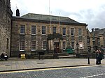 Başka bir resim yükle
|
| 213, 215 Yüksek Sokak | | | | 55 ° 58′33″ K 3 ° 36′21″ B / 55.975808 ° K 3.605922 ° B / 55.975808; -3.605922 (213, 215 Yüksek Sokak) | Kategori B | 37421 | 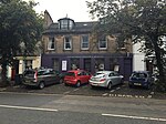 Başka bir resim yükle
|
| 297, 299 High Street, İstinat Duvarlı Batı Limanı Evi | | | | 55 ° 58′33″ K 3 ° 36′34″ B / 55.975707 ° K 3.609555 ° B / 55.975707; -3.609555 (297, 299 High Street, İstinat Duvarlı Batı Limanı Evi) | A Kategorisi | 37430 | 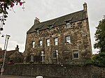 Başka bir resim yükle
|
| Grange House Ahır ve Kır Evi | | | | 55 ° 59′32″ K 3 ° 36′17 ″ B / 55.992225 ° K 3.604599 ° B / 55.992225; -3.604599 (Grange House Ahır ve Kır Evi) | Kategori C (S) | 12973 | |
| Wairdlaw Kireç Fırınları | | | | 55 ° 56′24″ K 3 ° 36′36″ B / 55.939875 ° K 3.609878 ° B / 55.939875; -3.609878 (Wairdlaw Kireç Fırınları) | Kategori B | 12986 | |
| Avon Su Kemeri, Edinburgh ve Glasgow Union Kanalı Su Kemeri | | | | 55 ° 57′51″ K 3 ° 39′22″ B / 55.964173 ° K 3.655986 ° B / 55.964173; -3.655986 (Avon Su Kemeri, Edinburgh ve Glasgow Union Kanalı Su Kemeri) | A Kategorisi | 7468 | |
| Burgh Mill Lane, Burgh Mill House ve Bitişik Ek Bina | | | | 55 ° 58′29 ″ K 3 ° 37′52″ B / 55.974659 ° K 3.631146 ° B / 55.974659; -3.631146 (Burgh Mill Lane, Burgh Mill House ve Bitişik Ek Bina) | Kategori C (S) | 7474 | |
| Cauldhame Farmhouse, Steading And Horsemill | | | | 55 ° 57′42″ K 3 ° 34′59″ B / 55.96178 ° K 3.583041 ° B / 55.96178; -3.583041 (Cauldhame Farmhouse, Steading And Horsemill) | Kategori B | 7476 | |
| 259, 261 High Street | | | | 55 ° 58′33″ K 3 ° 36′28″ B / 55.975855 ° K 3.607815 ° B / 55.975855; -3.607815 (259, 261 High Street) | Kategori B | 47560 | 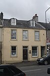 Başka bir resim yükle
|
| 78, 80 High Street | | | | 55 ° 58′37″ K 3 ° 35′56″ B / 55.976978 ° K 3.598839 ° B / 55.976978; -3.598839 (78, 80 High Street) | Kategori B | 37447 | |
| 3 Kirkgate | | | | 55 ° 58′39 ″ K 3 ° 36′04 ″ B / 55.977588 ° K 3.601011 ° B / 55.977588; -3.601011 (3 Kirkgate) | Kategori B | 37464 |  Başka bir resim yükle
|
| Blackness Road, St Michael's Church and Presbytery (Roman Katolik) | | | | 55 ° 58′44″ K 3 ° 35′41″ B / 55.978792 ° K 3.594779 ° B / 55.978792; -3.594779 (Blackness Road, St Michael's Church and Presbytery (Roman Katolik)) | Kategori B | 37359 | 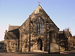 Başka bir resim yükle
Daha fazla görsele bakın |
| 12 Haç | | | | 55 ° 58′38″ K 3 ° 36′01 ″ B / 55.977239 ° K 3.600212 ° B / 55.977239; -3.600212 (12 Haç) | Kategori C (S) | 37365 | |
| Edinburgh Yolu, Rosebank | | | | 55 ° 58′35″ K 3 ° 35′10 ″ B / 55.976494 ° K 3.586222 ° B / 55.976494; -3.586222 (Edinburgh Yolu, Rosebank) | Kategori C (S) | 37369 | |
| High Street, St Michael's Well | | | | 55 ° 58′36″ K 3 ° 35′51″ B / 55.976691 ° K 3.597417 ° B / 55.976691; -3.597417 (High Street, St Michael's Well) | A Kategorisi | 37383 | 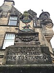 Başka bir resim yükle
|
| 29, 31 High Street Postanesi | | | | 55 ° 58′35″ K 3 ° 35′52″ B / 55.976524 ° K 3.597842 ° B / 55.976524; -3.597842 (29, 31 High Street Postanesi) | Kategori B | 37385 | 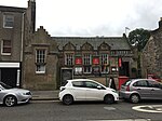 Başka bir resim yükle
|
| 89, 91 High Street | | | | 55 ° 58′37″ K 3 ° 36′02 ″ B / 55.97681 ° K 3.600691 ° B / 55.97681; -3.600691 (89, 91 High Street) | Kategori B | 37398 |  Başka bir resim yükle
|
| 145 High Street | | | | 55 ° 58′34 ″ K 3 ° 36′13 ″ B / 55.976198 ° K 3.603598 ° B / 55.976198; -3.603598 (145 High Street) | Kategori C (S) | 37411 | |
| 257 High Street | | | | 55 ° 58′33″ K 3 ° 36′28″ B / 55.975857 ° K 3.607671 ° B / 55.975857; -3.607671 (257 High Street) | Kategori B | 37424 |  Başka bir resim yükle
|
| 275 High Street ve 18, 20 St John's Avenue | | | | 55 ° 58′33″ K 3 ° 36′30″ B / 55.975813 ° K 3.608262 ° B / 55.975813; -3.608262 (275 High Street ve 18, 20 St John's Avenue) | Kategori B | 37428 |  Başka bir resim yükle
|
| Grange Evi, Duvarlı Bahçe | | | | 55 ° 59′27″ K 3 ° 36′24″ B / 55.99075 ° K 3.606734 ° B / 55.99075; -3.606734 (Grange Evi, Duvarlı Bahçe) | Kategori C (S) | 12974 | |
| Airngarth Tepesi, Umut Anıtı | | | | 55 ° 59′37″ K 3 ° 36′00 ″ B / 55.993685 ° K 3.600122 ° B / 55.993685; -3.600122 (Airngarth Tepesi, Umut Anıtı) | Kategori B | 7467 | |
| Bonnytoun Ev Çiftliği ve Bitişik Yönlendirme | | | | 55 ° 59′15″ K 3 ° 35′28″ B / 55.987512 ° K 3.591002 ° B / 55.987512; -3.591002 (Bonnytoun Ev Çiftliği ve Bitişik Yönlendirme) | Kategori B | 7471 | |
| Doğu Belsyde, Edinburgh ve Glasgow Union Kanal Köprüsü 47 | | | | 55 ° 58′01 ″ K 3 ° 38′14″ B / 55.966876 ° K 3.637308 ° B / 55.966876; -3.637308 (Doğu Belsyde, Edinburgh ve Glasgow Union Kanal Köprüsü 47) | Kategori B | 7480 |  Başka bir resim yükle
Daha fazla görsele bakın |
| 56-60 (Hatta Nos) High Street | | | | 55 ° 58′37″ K 3 ° 35′53″ B / 55.976942 ° K 3.59818 ° B / 55.976942; -3.59818 (56-60 (Hatta Nos) High Street) | Kategori C (S) | 37442 | |
| 62, 64 High Street | | | | 55 ° 58′37″ K 3 ° 35′54″ B / 55.976913 ° K 3.598307 ° B / 55.976913; -3.598307 (62, 64 High Street) | Kategori C (S) | 37443 | |
| 212, 214 Rear High Street, Eski Tabakhane | | | | 55 ° 58′36 ″ K 3 ° 36′16 ″ B / 55.976572 ° K 3.604543 ° B / 55.976572; -3.604543 (212, 214 Rear High Street, Eski Tabakhane) | Kategori C (S) | 37454 | |
| 220 High Street | | | | 55 ° 58′35″ K 3 ° 36′17 ″ B / 55.976283 ° K 3.604643 ° B / 55.976283; -3.604643 (220 High Street) | Kategori C (S) | 37456 | |
| High Street, Baird Hall | | | | 55 ° 58′34 ″ K 3 ° 36′18″ B / 55.976225 ° K 3.604913 ° B / 55.976225; -3.604913 (High Street, Baird Hall) | Kategori C (S) | 37458 | |
| Kirkgate And The Cross, Burgh Halls (Eski Belediye Binası ve Eski İlçe Binası) | | | | 55 ° 58′39 ″ K 3 ° 36′02 ″ B / 55.977602 ° K 3.600659 ° B / 55.977602; -3.600659 (Kirkgate And The Cross, Burgh Halls (Eski Belediye Binası ve Eski İlçe Binası)) | Kategori B | 37465 | |
| 16 Lion Well Wynd Ve Sınır Duvarı | | | | 55 ° 58′32″ K 3 ° 36′16 ″ B / 55.975485 ° K 3.604466 ° B / 55.975485; -3.604466 (16 Lion Well Wynd Ve Sınır Duvarı) | Kategori C (S) | 37476 | |
| Manse Road, Glebe House, Gatepiers ve Sınır Duvarı ile Eski Linlithgow Manse | | | | 55 ° 58′10 ″ K 3 ° 35′48″ B / 55.969314 ° K 3.596696 ° B / 55.969314; -3.596696 (Manse Road, Glebe House, Gatepiers ve Sınır Duvarı ile Eski Linlithgow Manse) | Kategori B | 37484 | |
| 1 Sınır Duvarlı Kraliyet Terası | | | | 55 ° 58′31″ K 3 ° 36′10 ″ B / 55.975275 ° K 3.602711 ° B / 55.975275; -3.602711 (1 Sınır Duvarlı Kraliyet Terası) | Kategori C (S) | 37490 | |
| 6 Kraliyet Terası | | | | 55 ° 58′30″ K 3 ° 36′13 ″ B / 55.974974 ° K 3.603676 ° B / 55.974974; -3.603676 (6 Kraliyet Terası) | Kategori B | 37492 | |
| Sınır Duvarları ve Ağ Geçitleri ile 8, 9 Kraliyet Terası | | | | 55 ° 58′30″ K 3 ° 36′15 ″ B / 55.974905 ° K 3.604186 ° B / 55.974905; -3.604186 (Sınır Duvarları ve Kapıları Olan 8, 9 Kraliyet Terası) | Kategori B | 37494 | |
| Union Road, Sınır Duvarları ve Kapısı Olan Lindisfarne | | | | 55 ° 58′30″ K 3 ° 36′27″ B / 55.974997 ° K 3.607427 ° B / 55.974997; -3.607427 (Union Road, Sınır Duvarları ve Kapılı Lindisfarne) | Kategori B | 37504 | |
| Bell's Burn, Baron's Hill | | | | 55 ° 58′43 ″ K 3 ° 35′33″ B / 55,978697 ° K 3,592419 ° B / 55.978697; -3.592419 (Bell's Burn, Baron's Hill) | Kategori B | 37356 | |
| 57, 59 High Street | | | | 55 ° 58′36 ″ K 3 ° 35′58″ B / 55.976604 ° K 3.59932 ° B / 55.976604; -3.59932 (57, 59 High Street) | Kategori C (S) | 37391 | |
| 147 High Street | | | | 55 ° 58′34 ″ K 3 ° 36′13 ″ B / 55.976187 ° K 3.603694 ° B / 55.976187; -3.603694 (147 High Street) | Kategori C (S) | 37412 | |
| 165 High Street | | | | 55 ° 58′34 ″ K 3 ° 36′16 ″ B / 55.976088 ° K 3.604395 ° B / 55.976088; -3.604395 (165 High Street) | Kategori B | 37416 |  Başka bir resim yükle
|
| 177, 179 (Tek Sayılar) High Street The Crown Arms | | | | 55 ° 58′33″ K 3 ° 36′18″ B / 55.975955 ° K 3.604966 ° B / 55.975955; -3.604966 (177, 179 (Tek Sayılar) High Street The Crown Arms) | Kategori B | 37419 |  Başka bir resim yükle
|
| Philipstoun, Edinburgh ve Glasgow Union Canal Su Kemeri | | | | 55 ° 58′32″ K 3 ° 31′30″ B / 55.975426 ° K 3.524913 ° B / 55.975426; -3.524913 (Philipstoun, Edinburgh ve Glasgow Union Canal Su Kemeri) | Kategori B | 12981 | |
| Ekran Duvarı ve Antrenör Kemeri Dahil Preston Evi | | | | 55 ° 57′54 ″ K 3 ° 36′37″ B / 55.965111 ° K 3.610317 ° B / 55.965111; -3.610317 (Ekran Duvarı ve Antrenör Kemeri Dahil Preston Evi) | A Kategorisi | 12983 | |
| 38-44 (Even Nos) High Street, Hamilton's Land | | | | 55 ° 58′37″ K 3 ° 35′52″ B / 55.976868 ° K 3.597664 ° B / 55.976868; -3.597664 (38-44 (Even Nos) High Street, Hamilton's Land) | A Kategorisi | 37438 |  Başka bir resim yükle
|
| 46, 48 High Street, Hamiltons 'Land | | | | 55 ° 58′37″ K 3 ° 35′52″ B / 55.976902 ° K 3.59781 ° B / 55.976902; -3.59781 (46, 48 High Street, Hamiltons 'Land) | A Kategorisi | 37439 | |
| 66, 68 High Street | | | | 55 ° 58′37″ K 3 ° 35′54″ B / 55.977011 ° K 3.598423 ° B / 55.977011; -3.598423 (66, 68 High Street) | Kategori C (S) | 37444 | |
| 96, 98 High Street | | | | 55 ° 58′38″ K 3 ° 35′58″ B / 55.977157 ° K 3.599583 ° B / 55.977157; -3.599583 (96, 98 High Street) | Kategori C (S) | 37449 | |
| 102, 104 Yüksek Sokak | | | | 55 ° 58′38″ K 3 ° 35′59″ B / 55.977191 ° K 3.599793 ° B / 55.977191; -3.599793 (102, 104 Yüksek Sokak) | Kategori C (S) | 37451 | |
| 216, 218 Yüksek Sokak | | | | 55 ° 58′35″ K 3 ° 36′16 ″ B / 55.976302 ° K 3.604532 ° B / 55.976302; -3.604532 (216, 218 Yüksek Sokak) | Kategori C (S) | 37455 | |
| Market Lane, Linlithgow Masonik Köşkü | | | | 55 ° 58′39 ″ K 3 ° 36′01 ″ B / 55.977554 ° K 3.600145 ° B / 55.977554; -3.600145 (Market Lane, Linlithgow Masonik Köşkü) | Kategori C (S) | 37487 |  Başka bir resim yükle
|
| 1-3 (Tek Sayılar) Preston Yolu | | | | 55 ° 58′32″ K 3 ° 36′39 ″ B / 55.975557 ° K 3.610719 ° B / 55.975557; -3.610719 (1-3 (Tek Sayılar) Preston Yolu) | Kategori B | 37488 | |
| 20 İstinat Duvarı ve Korkuluklu Royal Teras | | | | 55 ° 58′29 ″ K 3 ° 36′23″ B / 55.974704 ° K 3.606501 ° B / 55.974704; -3.606501 (20 İstinat Duvarı ve Korkuluklu Royal Teras) | Kategori C (S) | 37498 | |
| 6 Union Road ve Lion Well Wynd | | | | 55 ° 58′31″ K 3 ° 36′16 ″ B / 55.975388 ° K 3.604382 ° B / 55.975388; -3.604382 (6 Union Road ve Lion Well Wynd) | Kategori C (S) | 37503 | |
| Back Station Road, Edinburgh ve Glasgow Union Canal Su Kemeri | | | | 55 ° 58′33″ K 3 ° 35′42″ B / 55.975896 ° K 3.595012 ° B / 55.975896; -3.595012 (Back Station Road, Edinburgh ve Glasgow Union Canal Su Kemeri) | Kategori B | 37354 | |
| Blackness Yolu, Boghall Lodge | | | | 55 ° 59′03 ″ K 3 ° 34′48″ B / 55.984069 ° K 3.579976 ° B / 55.984069; -3.579976 (Blackness Yolu, Boghall Lodge) | Kategori B | 37357 | |
| Blackness Road, Low Port İlköğretim Okulu, (Eski Linlithgow Academy) | | | | 55 ° 58′42″ K 3 ° 35′48″ B / 55.978392 ° K 3.596557 ° B / 55.978392; -3.596557 (Blackness Road, Low Port İlköğretim Okulu, (Eski Linlithgow Academy)) | Kategori B | 37358 |  Başka bir resim yükle
|
| 5 Haç, Haç Ev | | | | 55 ° 58′38″ K 3 ° 36′04 ″ B / 55.977326 ° K 3.601145 ° B / 55.977326; -3.601145 (5 Haç, Haç Ev) | A Kategorisi | 37363 |  Başka bir resim yükle
|
| Edinburgh Yolu, St Magdalene'nin İçki Fabrikası Maltlama Ahırı ve Çift Fırın | | | | 55 ° 58′35″ K 3 ° 35′33″ B / 55,976513 ° K 3,592425 ° B / 55.976513; -3.592425 (Edinburgh Yolu, St Magdalene'nin İçki Fabrikası Maltlama Ahırı ve Çift Fırın) | Kategori C (S) | 37371 |  Başka bir resim yükle
Daha fazla görsele bakın |
| 1 High Street, The Star Ve Jartiyer Otel | | | | 55 ° 58′37″ K 3 ° 35′47″ B / 55.97684 ° K 3.596301 ° B / 55.97684; -3.596301 (1 High Street, The Star Ve Jartiyer Otel) | Kategori B | 37381 |  Başka bir resim yükle
Daha fazla görsele bakın |
| 53, 55 Ağ Geçitleri, Geçitler, Kapılar ve Korkuluklarla Yüksek Cadde The Royal Bank Of Scotland | | | | 55 ° 58′36 ″ K 3 ° 35′57″ B / 55.976651 ° K 3.599146 ° B / 55.976651; -3.599146 (53, 55 Ağ Geçitleri, Geçitler, Kapılar ve Korkuluklarla Yüksek Cadde The Royal Bank Of Scotland) | Kategori B | 37390 | 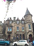 Başka bir resim yükle
|
| 61 Yüksek Sokak | | | | 55 ° 58′36 ″ K 3 ° 35′58″ B / 55.976755 ° K 3.599454 ° B / 55.976755; -3.599454 (61 Yüksek Sokak) | Kategori C (S) | 37392 | |
| 73,75 High Street | | | | 55 ° 58′36 ″ K 3 ° 36′00 ″ B / 55.976738 ° K 3.600047 ° B / 55.976738; -3.600047 (73,75 High Street) | Kategori C (S) | 37396 | |
| 77, 79 High Street | | | | 55 ° 58′37″ K 3 ° 36′01 ″ B / 55.976808 ° K 3.600194 ° B / 55.976808; -3.600194 (77, 79 High Street) | Kategori C (S) | 37397 | |
| 267, 269 High Street | | | | 55 ° 58′33″ K 3 ° 36′29 ″ B / 55.975798 ° K 3.608069 ° B / 55.975798; -3.608069 (267, 269 High Street) | Kategori C (S) | 37426 | |
| 271, 273 Yüksek Cadde Portcullis | | | | 55 ° 58′33″ K 3 ° 36′29 ″ B / 55.975833 ° K 3.608134 ° B / 55.975833; -3.608134 (271, 273 Yüksek Cadde Portcullis) | Kategori C (S) | 37427 | |
| Gig-House ve Sınır Duvarı ile Gateside Çiftlik Evi | | | | 55 ° 57′56″ K 3 ° 31′26″ B / 55.965619 ° K 3.523758 ° B / 55.965619; -3.523758 (Gig-House ve Sınır Duvarı ile Gateside Çiftlik Evi) | Kategori C (S) | 12970 | |
| Avon Nehri, Edinburgh - Glasgow Demiryolu Viyadüğü | | | | 55 ° 58′29 ″ K 3 ° 38′00 ″ B / 55.974709 ° K 3.63344 ° B / 55.974709; -3.63344 (Avon Nehri, Edinburgh - Glasgow Demiryolu Viyadüğü) | A Kategorisi | 12985 | 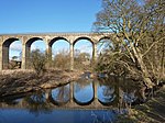 Başka bir resim yükle
Daha fazla görsele bakın |
| Bridgend Çiftlik Evi | | | | 55 ° 58′09 ″ K 3 ° 32′00 ″ B / 55,969049 ° K 3,533347 ° B / 55.969049; -3.533347 (Bridgend Çiftlik Evi) | Kategori B | 7473 | |


